Part I: Anchorage, Alaska to Dawson City, Yukon Territories
This is the first instalment in a series chronicling the adventures of the author; her husband, Adam; and two-year-old daughter, Kiersten, as they travelled by car from Alaska to Louisiana in summer 2008.
 Normal people have normal summer vacations. They go to the beach for the weekend. They camp in the mountains for a week. They kick back on the patio and relax.
Normal people definitely do not spend three weeks driving across the continent from Alaska to Louisiana.
they’re missing a lot.
Two years ago, when my husband and I drove from Florida to Alaska?five-week-old daughter in tow?friends and relatives thought we were crazy. And in retrospect, we probably were.
But without question, crazy enough to do it again?without blinking an eye.
That’s why we found ourselves on the road again this past July. We knew that few things could compare with the chance to experience the vast and varied landscapes of North America, from the high north to the Deep South. And we knew that no headache, argument, tantrum, or $70 gas receipt could make us regret our adventure driving from almost one end of the continent to the other.
Day 1: Anchorage, AK to Tok, AK
It’s the first day on the road, and despite a resolve to leave at the break of day, we head out close to lunchtime. We’ve settled on travelling approximately 300 miles a day?which translates as six or seven hours?although in more remote parts we’ll have to adjust that figure. In many northern areas, there’s little in the way of amenities and hotels (or even humans) for hundreds of miles, so our itinerary is largely limited by where the towns are located.
Although we’re still in the land of the midnight sun?or maybe more like 11 p.m. sun at this point?and could travel safely later, we’re somewhat bound by Kiersten’s schedule. Her good humour gives out by suppertime (earlier if she doesn’t nap), so we hope to reach each day’s destination by five in the afternoon.
we’re using the Milepost, a mile-by-mile itinerary of the Alaska Highway and most of the other major routes in Alaska and northwestern Canada. Aside from its usefulness for planning our rest stops, we’re especially enjoying the historical, geographical, and cultural tidbits about the places we’re passing through. It’s helping us connect with the area in a way we couldn’t have experienced without it.
A few hours into the drive, I’m noticing one major difference between this trip and our 2006 drive: the traffic, or rather the surprising lack of it. Two years ago there were long lines of RVs, but now we’re the only car on the highway for large stretches. We suspect that skyrocketing fuel prices have turned people off road trips this summer. It’s further confirmation that this drive may have been a crazy idea!
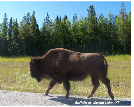
There also doesn’t seem to be much wildlife out and about. That can’t be explained by the rising cost at the pump, so we’re a bit mystified. we’ll be driving through a lot of remote areas, so we’re hoping to get some good wildlife sightings in. In particular, we want to see a bear. Despite constant warnings about bear safety, we didn’t even see a bear paw print during our two years in Alaska. we’re determined to see one during this trip, no matter what.
 For a freedom-loving two-year-old suddenly strapped in a car seat for six to eight hours a day, Kiersten’s doing well, but She’s almost entirely dependent on us for amusement. Constantly entertaining her with books, puppets, games, songs, and other clown tricks is exhausting me?not to mention giving me a permanent crick in my neck from twisting around. At this point, three weeks on the road is looking interminable. we’re glad we bought her some CDs of kiddie songs; as annoying as they are in themselves (how many times have we heard ?Old MacDonald??), they’re giving us some relief.
Although we all started out in good spirits, our sense of adventure wanes as the afternoon wears on. Kiersten, overexcited by the novelty of travel, has skipped her nap and is grouchy and bored. Nothing seems to cheer her up. After almost 30 long minutes of singing, reading, explaining, playing, and even putting ?Old MacDonald? on repeat, she eventually falls asleep, but not after enough screaming that we’re almost regretting this trip already.
That evening we arrive in Tok, Alaska, an important junction town: It’s here that travellers coming to Alaska can turn south toward Anchorage or west to Fairbanks. Travelling in the direction of Canada, there are two routes: the famous Alaska Highway southeast toward Whitehorse, or the Taylor Highway/Top of the World Highway to Dawson City, Yukon Territories. Although we’ll link up with the Alaska Highway in Whitehorse later, we’ve decided to take the northerly route from Tok so that we’ll have the chance to visit Dawson City. It will put us a day out of our way, but we’d hate to miss the opportunity when we’re so close.
Day 2: Tok, Alaska to Dawson City, Yukon Territories
The next morning, we leave late (again), but half an hour earlier than yesterday, so we’re doing better. I’m behind the wheel, supposedly to give Adam a break from driving, but secretly to give myself a break from being court jester to the Princess in the back seat. There’s still almost no traffic, although we manage to get delayed by construction for a while. The detour is so winding that for a few miles we’re not sure whether we’re being rerouted to some dead end by a practical joker.
Most of the landscape we pass through this morning is dead forest?acres upon acres of blackened trees, as far as the eye can see. A 2004 forest fire here destroyed millions of acres, and regrowth, if any, seems slow. It seems to have scared off the animals too, as we don’t even see so much as a chipmunk, let alone a bear.
Around lunchtime we arrive in the tiny settlement of Chicken. Legend claims it was supposed to be called Ptarmigan, but was named after a more common bird because the settlers couldn’t agree on the spelling.
Chicken’s a very small community, with a population of 21 in the summer?and only six people remain there year-round. It’s remote, much more so than most of the places we’ll pass through this trip; there are no telephones and no flush toilets in town, although surprisingly, they do have Internet. Before the Internet, business owners had to give their order lists to bus drivers and trust they’d fax them in when they reached a town. And regardless of the method, those staying the winter need to order their winter supplies well in advance, because once the snow hits, Chicken’s cut off from the rest of the world. It’s a different life, but the community seems like a family; out in the wilderness, you pretty much have to be able to rely on one another.
Chicken’s notable for something else, at least for those driving the Taylor Highway toward Dawson City: It’s approximately where the pavement ends. As we drive along the mud-gravel-dirt mix and bounce through ruts, I keep thinking that I’m not on a road at all, but rather driving toward the barn behind some farm back in Ontario. We can only move at 30 mph without permanently damaging our protesting car, and we realize just why MapQuest recommended seven hours for a 180-mile trip.
 Just past Chicken is the turnoff for Eagle, Alaska. It’s a remote settlement along the Yukon River, and It’s also home to Yukon-Charley Rivers National Park. The US National Park Service has a ?passport? program for collecting stamps and stickers from national parks and historic sites, and we’ve become obsessed with filling our book. Eagle is only 100 miles from the highway we’re on, and we’d been desperately clinging to the hope of making a side trip for that stamp?but when we realize that the road conditions are even worse, we regretfully decide to skip it and press on to Dawson City. One hundred miles isn’t far, except when it takes four hours to go one way.
Late in the afternoon, we cross into Canada again! But it doesn’t really feel like home, since It’s such remote wilderness out here. we’re now on the Top of the World Highway, which I think should be called the Top of the Mountain highway; we’re level with or above the rain clouds and can see steep valleys below us. Although the downpour we drive through makes the road a little slippery, It’s doing wonders to clean off the mud we picked up driving from Chicken.
Eventually, the road twists and turns downwards and we need to slam on the brakes; we’re suddenly at the Yukon River, which lies between the highway we’re driving and Dawson City.
There’s a free ferry that operates during the summer to bring residents and visitors back and forth between Dawson City and West Dawson on the opposite bank. During the northern winters, the Yukon freezes solidly enough for traffic to cross freely. However, during breakup and thaw in late spring, the river can’t be crossed safely by any means, and the residents of West Dawson are cut off from the town until the water’s clear enough for the ferry to operate.
we’re curious as to why there’s no bridge across the river; later, we learn that they’ve been trying to put one in for years, but conflicting property interests and concerns about damaging historic sites keep stalling the project.
That night, we stay in a cute bed and breakfast downtown. we’re excited for tomorrow: no early morning driving, just sightseeing for most of the day. We can’t wait to explore the ?Paris of the North?!